This is a list of all of my landouts, with commentary and links to satellite imagery. So far all of them have been in the Shenandoah Valley in Virginia, with most of them around the northern end of the Massanutten range.
New Market Airport 8W2 (38.6554°N 78.7092°W)
Normally I wouldn't count an airport as a true landout, but this one gets special treatment because it was my first cross country. The airport at New Market is a small GA field, with a 3000ft paved runway, a small ramp, and very easy access from the road.
Google Maps Live Search Maps
View Larger Map
A hay field roughly 5 miles northeast of Keezletown, VA (38.4708°N 78.7584°W)
This was my first true landout, which occurred after failing to jump the nearby gap on the Massanutten ridge. It's a fairly nice rolling hay field, although a bit cramped and with trees on both ends. There is a golf course about half a mile to the east which would probably be a much better place to land.
Google Maps Live Search Maps
View Larger Map
Frederick County water treatment plant about three miles east of Strasburg, VA (38.9816°N 78.2898°W)
I took off into what looked like an awesome day but which turned out to be pretty poor. After a valiant struggle, I chose this airport-sized field. It was cut short and is about 3000 feet long, so there was no trouble getting into it. Getting out was an entirely different story. Despite landing next to a driveway running through the middle, it turned out that there was a locked gate and nobody on duty that day. We finally managed to find someone who knew someone who worked there, and got us in so we could retrieve the glider.
Google Maps Live Search Maps
View Larger Map
Woodstock Middle School parking lot, Woodstock, VA (38.8644°N 78.5263°W)
I very nearly fell out of the lift but finally performed a low save while practically in the traffic pattern of the Front Royal airport. From there I gained well over 3000 feet and started heading down the valley. Unfortunately my luck didn't last, and I was brought down by an unfortunate bout of airsickness. I can only blame the airsickness for my choice of landing spot because this was a terrible choice. The parking lot is ridiculously small and is ringed by tall lamp posts. I was able to get it in and stopped with no damage, but involved a rather hairy stunt, flying right between two of the fairly closely spaced lamp posts in order to make it down in time. There are a lot of better choices in the area, so I can only claim that my brain wasn't quite working right at the time. This one is pretty much guaranteed to be a disaster in anything bigger than a 1-26.
Google Maps Live Search Maps
View Larger Map
Signal Knob Farms, a mile east of Strasburg, VA (38.9796°N 78.3344°W)
A bad choice of direction took me away from the lift, and it wasn't long before I had to pick a place to land. I chose a short-cropped section of a corn field. The field was fine, with no major obstructions, and plenty of room. It was a bit hard to get to, and we ended up having to carry the wings a short distance to the trailer, but it was nothing major. The most interesting part of this one came when a neighbor called 911 to report a plane crash, and emergency services showed up in force. The two reporters who followed them ended up writing a nice article about me.
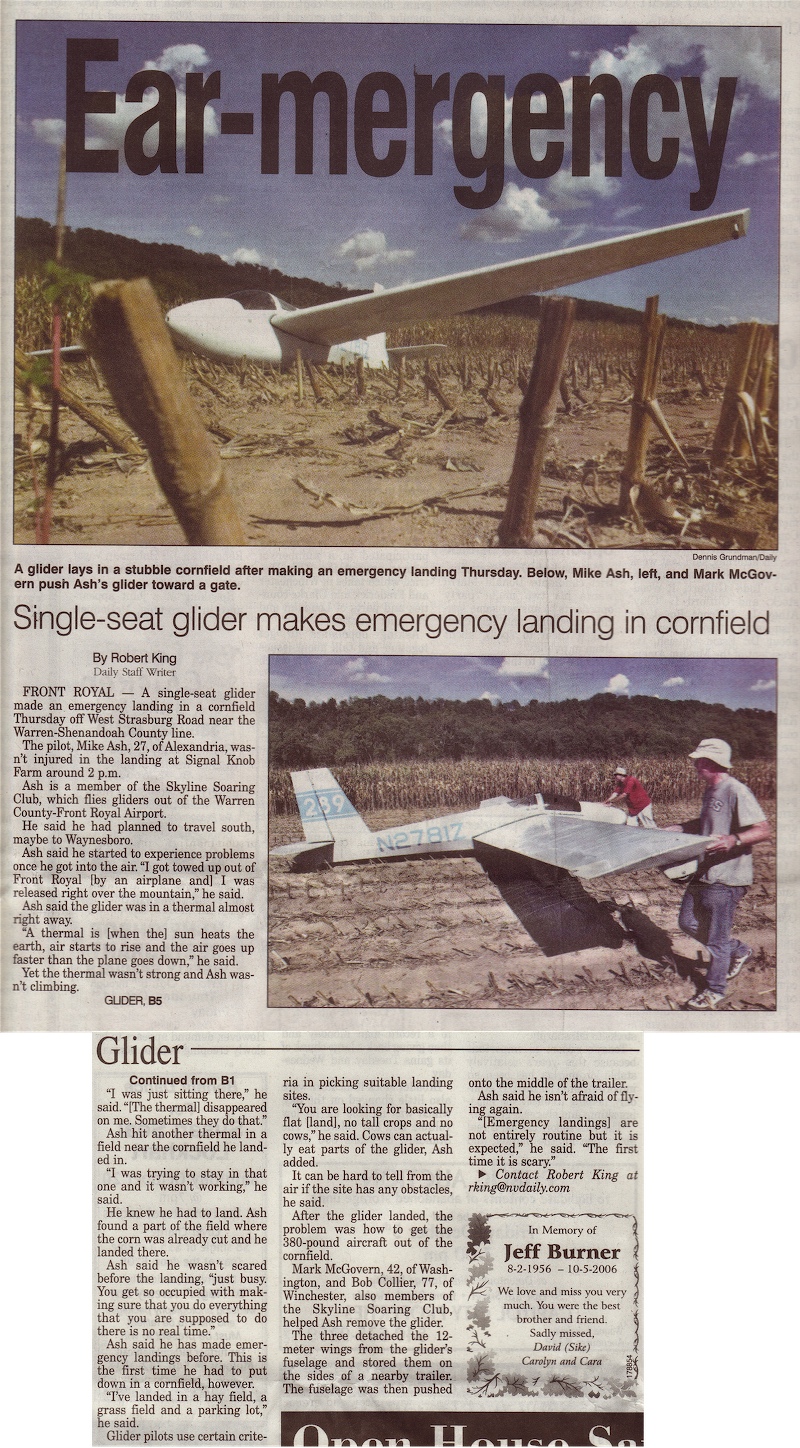
Google Maps Live Search Maps
View Larger Map
A hay field a mile east of Strasburg, VA (38.9771°N 78.3382°W)
This one is literally just across the river from the last one, and resulted from a foolish attempt to run the ridge on a day where the wind speed and direction just didn't support it. I even got to explain to the owners of the field that I was in fact the guy they had read the article about the week before. The field itself was nice and smooth, with hay bales to dodge but ample room between them. It is a bit short, however, with tall trees and powerlines on the southeastern side, which made it pretty tight quarters. The 1-26 handled it fine, but it would be chancy in anything faster.
Google Maps Live Search Maps
View Larger Map
A dirt field two miles northeast of Edinburg, VA (38.8311°N 78.5347°W)
Winds and thermals were not as expected, resulting in a very soft ridge which finally quit altogether at this point. This field had a very good slope to it and was very soft dirt which resulted in a really short rollout of probably under 100ft. Various obstructions on the downhill end didn't affect the approach too much due to being mostly below the slope. The only downside was that maneuvering the glider to disassemble it was pretty difficult on the soft ground.
Google Maps
View Larger Map
A driveway near Stanley, VA (38.5724°N 78.4597°W)
On a tricky day where the lift was only over the mountains and not under every cloud, I got forced into the valley. I found a last-ditch thermal at about 1500ft AGL. I spent 15 minutes in this thermal, examining the land below to pick my landing spot, so that when it finally gave out I was ready. I chose a very long driveway leading up to a hilltop house. Power lines on the approach end complicated matters a bit, but the driveway was long enough that it was not too difficult to clear them and make a comfortable landing. The owner of the house was not at home, but the neighbors were extremely friendly, and trailering the glider out was a piece of cake.
Google Maps
View Larger Map
A corn field near Harrisonburg, VA (38.3536°N 78.8355°W
I ran down to the south end of the Massanutted ridge and flew as far as I could past it. This was as far as I could go. It was a perfect location in every way: uphill, into the wind, corn cut extremely shot, and right next to the driveway. The farmer was extremely friendly and he and his friend both helped us put the glider away.
View Larger Map
Comments:
To meet the requirements for a Private or Commercial certificate or for an Instrument rating or to "exercise the privileges of a Recreational" certificate the flight must include a LANDING at a point MORE than 50NM from the point of original departure.
A the cost of this is lower than the very limited scope for mass production would allow, and the risk of a copy being obtained and defeated as practice is removed.
Reforestation is the commercial logging industry's answer to the large-scale destruction of old growth forests, but a planted forest rarely replicates the biodiversity and complexity of a natural forest.
Great article! <a
Thanks, that was a really cool!
What a Super site!
Vos filles trans adorées vous attendent sur le site Travesti Chat. Venez ici maintenant et discutez avec eux !
travestiechat.fr
travestiechat.fr
You've mentioned all your reader needs to know. Thank you!
Great and informational website.
Great knowledge!!
Comments RSS feed for this page
Add your thoughts, post a comment:
Spam and off-topic posts will be deleted without notice. Culprits may be publicly humiliated at my sole discretion.
Log each and every flight(s) in which you fly 50NM or more to a distant landing as CROSS COUNTRY distance flights flown and logged. You may find this useful when or if you apply for other Airman ratings or higher Airman Certificates.
Know, The FAA does not consider a flight a cross country flight without a landing 50NM or more distant to a full stop.
Strange it may seem, that an airman flying glider, experimental or std airworthiness, may fly great distances even 1000Km or more and it would not be counted as Cross Country Flight by FAA unless he landed that distance away to a full stop .
If one landed 30miles short tho had flown many many miles FAA XC definition would grant you no XC for the flight.
Sad. True.
So if you did 1000Km Out and Return or 1000Km triangle, and returned to point of origin it is not Cross Country flight in FAA definition of Cross Country aircraft flight unless one were flying it under AirTransportPilot provisions of his Certificate and rating Glider (this would be a rare instance, and most ATP Airmen actually exercise or are limited to PP or CP privileges in glider these days. Only a few Airmen remain who hold ATP
Certificate with Glider rating with ATP privileges extant in glider.
Make your XC flights count for FAA, for additional ratings, and for insurers. Log XC as such meeting the definition of Cross Country Flight as stated by FAA CFRs.
Cross-Country Time
The basic definitions of cross-country time are found in 14 CFR Part 61.1 (b)(3). A cross-country flight is any flight that involves a landing at another airport and involves navigation.
This may be relevant to you when you are looking to qualify under Part 135 pilot requirements, since there this basic definition of cross-country is used. However, there is a difference in this basic definition and the requirements for cross-country flight to count as the appropriate aeronautical experience for a certificate or rating.
In essence:
To meet the requirements for a Private or Commercial certificate or for an Instrument rating or to "exercise the privileges of a Recreational" certificate the flight must include a LANDING at a point MORE than 50NM from the point of original departure.
For an ATP certificate the requirement is for a FLIGHT (not a landing) more than 50NM straight line distance from the point of departure.
Otherwise any landing at any other airport counts as cross-country time. This is generally important for people looking to meet the 14 CFR Part 135 PIC requirements.
Be of good heart.
Dancing on clouds,
Keep it up !
Jim Culp Asw-20C
comps nr USA
A Georgia Bulldog way down in Gator Country
Gainesville Florida metro area culpusa@aol.com